For business inquiries : (+971) 561803315
For special requests : (+971) 561803315
For business inquiries : (+971) 561803315
For special requests : (+971) 561803315
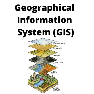
The Geographic Information Systems (GIS) 2024 training aims to provide participants with the foundational knowledge needed to understand and effectively utilize geographic information. Participants will learn to create thematic maps, deploy GIS systems, and manipulate geographic data to meet their organization's needs.
Module 1: Introduction to GIS
Understanding the basic concepts of Geographic Information Systems (GIS)
Exploring key tools and methods: creating, manipulating, editing, analyzing, and representing spatial information cartographically
Hands-on practice with software (e.g., ArcGIS) using real-world examples
Module 2: Advanced GIS
Mastering advanced tools and methods: creating, manipulating, editing, analyzing, and representing spatial information cartographically
Practical application of the software with real-world examples
Preparing files for integration into a GIS environment
Module 3: GIS Advanced Techniques
Advanced mastery of tools and methods: creating, manipulating, editing, analyzing, and representing spatial information cartographically
Full command of the software through practical exercises
Analyzing software-generated results and proposing appropriate solutions
Module 4: GIS Integration of Domain Knowledge
Integrating professional knowledge into geographic models
Analyzing specific needs and requirements
Designing a project tailored to those needs
Achieving autonomy in GIS practice and application within one's professional context